Heatwave Intensifies: UK Faces Threat of Yellow Thunderstorm Warning
Yellow Thunderstorm Warning Amid UK Heatwave in June 2025
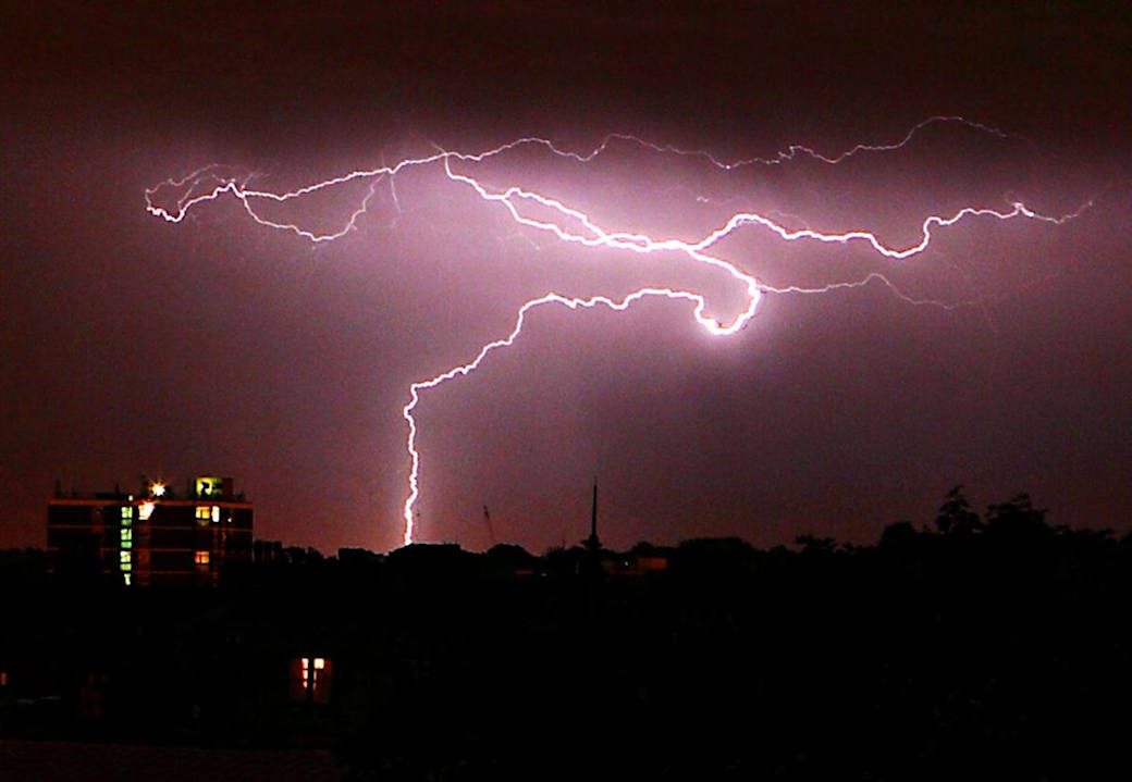
The Met Office has issued a yellow weather warning for thunderstorms across parts of northern England, the Midlands, and Wales, effective from 3:00 PM BST on Saturday, June 21, 2025, to 4:00 AM BST on Sunday, June 22, 2025. This warning coincides with an ongoing heatwave, with temperatures reaching up to 34°C in some areas, marking the hottest weather of 2025 so far. The combination of high temperatures and humidity is fueling the potential for scattered thunderstorms, which could bring frequent lightning, large hail, gusty winds, and heavy downpours, leading to possible disruptions and safety risks.
Details of the Thunderstorm Warning
- Affected Areas: The yellow warning covers the East Midlands, West Midlands, North East England, North West England, Yorkshire and the Humber, and parts of Wales. Major towns and cities included are Leicester, Nottingham, Durham, Newcastle, Greater Manchester, Merseyside, and York.
- Potential Impacts:
- Flash Flooding: Some areas could see 30-50 mm of rain in a few hours, potentially causing surface water flooding. This is significant, as the average June rainfall in the UK is 77.2 mm, meaning some locations could receive nearly half a month’s rain in a short period.
- Power Cuts: There is a slight chance of power outages affecting homes and businesses.
- Travel Disruptions: Spray and sudden flooding could lead to difficult driving conditions, road closures, and possible delays or cancellations to train and bus services.
- Property Damage: Lightning strikes, hail, or strong winds could damage buildings.
- Safety Risks: The Met Office warns of a small chance that communities could be cut off by flooded roads, posing risks to safety.
- Weather Dynamics: The thunderstorms are expected to develop during Saturday afternoon, lasting through the evening and moving northeastwards before clearing to the North Sea by early Sunday. While many areas may remain dry, the most intense storms could produce significant localized impacts. The high humidity and heat, driven by southerly winds and a high-pressure system drawing warm air from Western Europe, are contributing to the storm risk.
Heatwave Context
The UK is experiencing its first official heatwave of 2025, with temperatures exceeding the heatwave threshold (25-28°C for three consecutive days, varying by region) in several areas. Key points include:
- Temperature Peaks: On Friday, June 20, temperatures reached 32.2°C, the hottest day of 2025 so far, surpassing the previous high of 29.3°C recorded on May 1 in Kew Gardens, London. On Saturday, temperatures could hit 34°C in central and southeastern England, though this remains below the June record of 35.6°C set in 1976.
- Regional Records: Suffolk became the first area to officially enter a heatwave on Thursday, June 19, after temperatures surpassed 27°C for three consecutive days. Other areas, including Albemarle, Northumberland, and Newcastle, recorded temperatures close to 30°C, the hottest since July 2022. Scotland saw 27.7°C in Aviemore, Highlands, and Northern Ireland hit 27.1°C in Derrylin, County Fermanagh.
- Amber Heat-Health Alert: The UK Health Security Agency (UKHSA) has issued an amber heat-health alert for England, in force until 9:00 AM on Monday, June 23, 2025. This alert warns of significant impacts on health and social care services, particularly for those over 65 or with pre-existing conditions like respiratory or cardiovascular diseases. The high humidity, especially at night, with temperatures potentially not dropping below 17-18°C (and some areas facing “tropical nights” above 20°C), increases discomfort and health risks.
Broader Weather Context
The current heatwave is driven by a high-pressure system drawing warm, humid air from Western Europe, with France and Spain seeing temperatures near 40°C. However, a low-pressure system to the west is introducing instability, contributing to the thunderstorm risk. The Met Office notes that while the heatwave is expected to peak on Saturday, cooler and more unsettled weather will arrive from the Atlantic by Sunday, with temperatures dropping to the low to mid-20s in eastern England and high teens elsewhere. There are indications that heat may return later in the week.
The UK’s driest spring in over 100 years, particularly in Yorkshire (less than 50% of average rainfall) and parts of Wales (driest since 1990), has heightened the risk of surface water flooding, as dry ground struggles to absorb heavy rain. Additionally, the National Fire Chiefs Council reported a 717% surge in wildfires across England and Wales in 2025 (564 incidents compared to 2024), driven by dry conditions, prompting warnings about fire risks from barbecues and glass bottles.
Recommended Actions
The Met Office and UKHSA provide the following guidance to mitigate risks from thunderstorms and heat:
- Thunderstorm Preparedness:
- Flood Planning: Check if your location is at risk of flash flooding and prepare a flood plan and emergency kit.
- Secure Property: Before gusty winds arrive, secure movable objects like bins, garden furniture, trampolines, tents, gazebos, sheds, and fences.
- Travel Planning: Check road conditions and public transport timetables to avoid delays. Adjust travel plans if necessary.
- Power Outage Preparation: Gather torches, batteries, and mobile phone power packs to cope with potential power cuts.
- Heatwave Safety:
- Stay hydrated and avoid excessive physical activity during peak heat hours.
- Check on vulnerable individuals, such as the elderly or those with health conditions.
- Keep homes cool by closing curtains and windows during the day and using fans or air conditioning if available.
Public and Media Reaction
The thunderstorm warning and heatwave have sparked significant attention. Media outlets like BBC News, The Independent, Sky News, and The Telegraph have reported on the intensifying heat and storm risks, emphasizing potential disruptions. Posts on X, such as one from @metoffice on June 20, 2025, highlight the need to stay “#WeatherAware,” while @GBNEWS noted the yellow alert amid the amber heat caution. Public sentiment reflects concern over travel disruptions and safety, with some welcoming the heat for businesses like ice cream parlors but others worried about flooding and wildfires.
Conclusion
The yellow thunderstorm warning for parts of northern England, the Midlands, and Wales from Saturday afternoon to early Sunday, June 22, 2025, signals potential disruptions amid a record-breaking heatwave with temperatures up to 34°C. The storms, fueled by high heat and humidity, could bring flash flooding, power cuts, and travel issues, while the amber heat-health alert underscores risks to vulnerable populations. The Met Office advises proactive measures to mitigate impacts, as the UK navigates this intense weather period driven by competing high- and low-pressure systems. With cooler weather expected by Sunday, staying informed and prepared is crucial. For the latest updates, check the Met Office website or follow their X account.